


Words by Tyler Brilinski, Photos by Eric Volk @1stkingsilver, Max Reese, and Tyler Brilinski

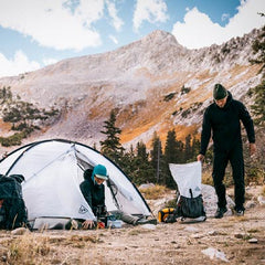
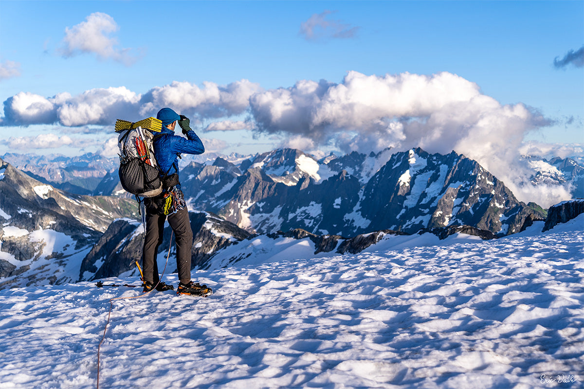
RECAP IF YOU’RE JUST GETTING HERE: Our big dream was to connect the dots across the wild and remote alpine landscape of Northern Washington. Starting from Mount Baker (near the Canadian border), traversing dozens of glaciers and hundreds of miles to another volcano at the south end of the range: Glacier Peak. We aimed to move fast, be light and keep things minimally technical.
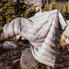
We’re back from the field! It has been a long journey: much longer than the 17 days spent on the route. Several summers of scouting and countless hours of scheming were necessary to even make an attempt. The goal was ambitious: a new and complete crossing of the North Cascades.
As the dust settles, we see that a quest like this really isn’t remembered as separate days. The trip was a series of peaks and valleys, both geologically and emotionally. Here we review a few of the more dramatic ups and downs.

HIGH: MOUNT BAKER!
The trip started with good momentum. We had excellent conditions on the Park Glacier. Snow consistency gave us a relatively simple climb, and the glacier held together just enough to give us passage to the top. There were some moments of suspense but nothing too stressful. We stood atop the morning of July 5th.


LOW: WHITE SALMON BUSHWHACK
This was an area I had scouted just a month earlier, assuring the group the schwack “wasn’t that bad!”… Boy, was I wrong (a theme that would develop further in days to come). We fought uphill against the alder for a few hours, in the hottest part of the day, naturally.


HIGH: NOOKSACK GLACIER
Our initial glimpse of this area brought the first real doubts about our mission’s larger success. None of us said it out loud, but it was clear we all had the same impression: the Nooksack Glacier looked impossible— a glacial traverse through a seemingly near-vertical cirque. Nevertheless we dug deep and managed an improbable yet efficient line through some of the sketchier terrain this trip would offer. Though energy was low, morale was high after clearing this first significant hurdle.


LOW: MINERAL MOUNTAIN
This was an unknown area before the trip. And we definitely underestimated it. The terrain was very steep, often 4th class scrambling, and totally overgrown in various shrubbery. Sometimes the vegetation offered a bit of “veggie belay” but it brought many other challenges with it. Often, it was the only connection we had to the ground. The route was uncertain and slow going, putting us far behind schedule.

LOW: CHALLENGER GLACIER
The Picket Range is perhaps the most epic of any place we would visit. Our triumphant return was spoiled by a day of heavy rain and high winds. A fitting welcome to an area as mythic as it is challenging. Though we visited in the peak of summer, the weather gods did not get the memo. We were soaking wet within the first hour and that didn’t change until well into the next day. What started with 5th class scrambling up wet and loose rock ended with navigating the Challenger Glacier in a whiteout. Tiptoeing along in hypothermic conditions, we powered through what were probably the hardest hours of the trip. It was a huge relief to set foot on the other side and bring the day to its soggy end.

HIGH: OUTRIGGER PEAK
After a day to dry out we surpassed the Fury Glacier (a nemesis feature from previous trips) and did some easy rock climbing in one of the most fantastic settings in North America. The sun was shining and so were we… if only for an instant…


LOW: MCMILLAN BASIN
Departing Outrigger, we quickly returned to reality. The southern half of the Pickets are a jumbled mess of debris zones, steep cliffs and other “surprises” that typically keep humans far away. We managed the terrain, but it cost us several trekking poles along with a good measure of blood, sweat and the other stuff.


HIGH: RESUPPLY PIZZA!!!


LOW: MOSQUITO HEAVEN
Though the terrain became somewhat more forgiving as we traveled southward, the concentration of bugs increased dramatically. Packs were heavy, the temperatures high and frustrations soared right alongside.

HIGH: PTARMIGAN TRAVERSE
Well‑traveled terrain that we had a lot of experience with. We started from one of my all‑time favorite camps and had a huge, productive day. In the evening we pushed the boundaries and with last light stumbled into another excellent site. We had stellar views of Glacier Peak, our eventual end point. For the first time on the trip, it appeared closer than our start point, Mount Baker. Morale was the highest we had seen since pizza day.


HIGH: CLOUDY PASS
To this point we had walked only a handful of miles on maintained trail. But with the terrain becoming less alpine and less glaciated to the south, we enjoyed a half day of trail hiking. The Cloudy Pass area was a real treat. Although we did see more people in one hour than we had seen in the two weeks prior.


LOW: CHIWAWA MOUNTAIN
This one has a high wrapped into it (as is usually the case). We faced some steep, slimy, scree‑covered slabs in our final ascent, which was immediately followed by the onset of rain. Our planned route over the next peak involved extended exposed scrambling. The rain made that prospect… unappealing, to say the least. We worked out a few alternatives and executed. With a bit of luck we beautifully bypassed the most significant hazards on Fortress Mountain.


HIGH: GLACIER PEAK
When we reached the standard high camp for GP we were indeed beginning to count the proverbial chickens. Mmmmm, chicken… who’s hungry? We damn sure were! Thankfully our friends also have an appetite for adventure. They greeted us at camp with whiskey, cake and companionship (not to mention the coolest dog to ever grace the high country!). The next morning we completed the uphill portion of this dream and finally stood atop Glacier Peak.


One might expect a flood of emotions at that point. Though the trip involved a lot of stuffing down our feelings, we are not especially stoic fellas. But for me at least, the summit had no big elation… nor the huge sense of relief that sometimes comes at these moments. Maybe it is because the “completion” of this project was experienced gradually, in several stages.
Though we had many moments of doubt in the first half of the trip, completing the terrain through the Pickets was a moment where we began to feel like we had made it. Again at the highway, and yet again when we wrapped around the south side of Dome Peak. Reaching Glacier Gap felt a bit like the finish line. Sure, the summit of GP was “the end”… but then again it really wasn’t over until we reached the car. Or was it the big Italian dinner a few hours later? Maybe when we got home and had a shower? Or once the photos, stories and memories had been processed?
Truthfully, it is as hard to define the end of this dream as it is to pinpoint exactly how it all started. But maybe that’s one of the things that separates a Dream from something that is merely a goal. Each can drive us powerfully but only a Dream truly transforms us… becomes a part of us… and that can be hard to part with. For those of us drawn to these high places, with dreams that seem foolish to the sane, that yearning is one of the most powerful forces in our lives. And at the completion of a dream we may feel a kind of emptiness, like something is missing… who are we without a direction for that yearning?
Of course we can simply clean the cannon and aim higher, again and again. But eventually that runs out too. There is a phrase “post trail depression”, and as it turns out no trail is required! Although it’s not really a “depression”, either… it’s more like grief. One of the meta‑lessons of these grand adventures is the ability to sit for a moment (or a week, or a month) without some new obsession or compulsive new mission. Letting the dust settle, let the toenails grow back, gain back some of that lost weight… and wait… for a new inspiration, another calling, the next chapter in what’s shaping up to be an awesome friggin' story.
BAKER TO GLACIER PEAK: BY THE NUMBERS
- 17 days
- 175.2 miles (73% off trail)
- 86k feet vertical gain (86% off trail), 88k feet lost
- Average vertical change per mile: 993 feet
- Average time from camp to camp each day: 14 hours
- Glaciers crossed: 26
- Times Tyler fell down: 23,680