




Quick Summary
Jada "Flo" Lippincott recounts an eight-day, 140-mile backpacking trip through Yellowstone's remote Bechler and Thorofare regions with her boyfriend Jon, chasing secluded waterfalls, hot-spring soaking pools, and wildlife far from the park's crowded main attractions. Along the way they navigate big mileage days, off-trail travel across Pitchstone Plateau and Two Ocean Plateau, river fords, and grizzly country, discovering spots like Mr. Bubbles, Dunanda Falls, and the remote Thorofare Ranger Station. It’s a love letter to Yellowstone's wilder corners, with a full nightly campsite itinerary included for readers wanting to follow the route.
Words and Photos by Jada “Flo” Lippincott @whereisjadaa
 Yellowstone National Park is unlike any other place on this planet. It was established as our world’s first national park in 1872, and rightfully so. Because of the caldera, the underground super volcano that IS Yellowstone, we have beautiful thermal features to ‘ooh’ and ‘ahh’ at.
These consist of geysers, which are water shooting out of the ground; hot springs, which are warm thermal pools of various shapes, sizes, and colors; mud pots, which are boiling mud; and fumaroles, which are steam vents. Everyone knows Old Faithful, one of the most famous geysers on the planet, whose eruptions follow a set schedule. That’s what makes it so crazy; you can literally time water erupting out of the ground, a totally natural phenomenon, down to a T. Every 90 minutes, plus or minus 10. Due to all the out-of-this-worldness that makes Yellowstone, it’s a pretty popular place. Giant parking lots filled by 10 am, boardwalks packed with eager tourists, and gift shops stocked with things nobody knew they needed. What if I told you about a couple of places in Yellowstone that are jaw-droppingly incredible, where you can explore and see no one for days? Well, truthfully told, if you were to go one mile from any popular area, you would quickly lose the tourists.
 I don’t think many young gals can say their first big-girl job was being a backcountry guide in Yellowstone National Park. I have spent many long, beautiful days traipsing around the park. I’ve picked up little bits and bobs from other guides too: ‘ooh, you need to check out this when you have a day off,’ or ‘you HAVE to go here next time you have a free day.’ Living in southwest Montana, I am also lucky to be only a stone's throw away from the park, like literally 20 miles. Because of this, I have heard from so many older, much wiser folks talk about places in the park that they went back in the day that they still think about today. My point is that I have compiled quite a list of places and things in Yellowstone that are far off the beaten path from anything I would ever do with clients. This park is 2.2 million acres; a huge area to try to see all of in one lifetime. I have to bite chunks off at a time. That is how I decided where I was going to go on my next Yellowstone adventure.
 Eight days, seven nights, 140 miles. 70 miles exploring the southwest part of the park, known as Bechler, and 70 miles exploring the southeast part of the park, known as the Thorofare. My boyfriend, Jon, caught wind of my desire for this trip, and we decided he too wanted to come along.
 Before we actually arrived at the trailhead to begin, we had to pick up our permits. My suggestion when applying for permits for the National Park Service: always have a rough itinerary of campsites you’re thinking about before you even set foot in the backcountry office. This will make things go a lot smoother. Some sites ended up being unavailable for the nights that we wanted, so we had to be flexible; some hiking days were going to be big, and some were going to be not-so-big. It’s best to go into the backcountry office with an open mind. We “purchased” our permits a few days before our trip, but the morning that we started, we had to stop by the office again to actually pick up the permit and the parking pass. Next thing we knew, we were ready to head on into the west gate of Yellowstone and begin our trek!
 If you look at the southwest section of Yellowstone on a map, you will see how remote it is. Most people begin their hikes at the Bechler Ranger Station, which is accessed from Idaho down a long, gravel road, but that was like five hours away from where we live. Instead, we decided to start at Lonestar Geyser trailhead, which is easily accessible in the middle of the park. This is also right on the CDT.
 Starting here meant that we had to hike 15 miles before we even entered the Bechler area, but we didn’t mind the extra hiking mileage. The terrain is flat, and we told ourselves that we could knock it out easily, and we did. The first few miles once you leave the trailhead are along an old road, which follows the Firehole River, which gets its name from all the thermal features dumping right into the river. The first thermal feature that you come across is Lonestar Geyser. It erupts every few hours, although we didn’t hang around to watch its next eruption. From the trailhead, we were about 17 miles from the first swimming hole, and then our campsite was a few more miles after that, so we had a big day planned. This first day was our only time during the day when it rained, so we were just kind of in ‘head-down, move-feet’ mode to keep warm as it rained.
 Most of the day was spent hiking through a beautiful lodgepole pine and subalpine fir forest. You get views of Dashing Falls, Grants Pass Cascades, Forks of Shoshone Falls, Douglas Knob Falls, Confusion Cascades, Littlesmouth Cascades, Forlorn Falls, and Ragged Falls. The coolest part of the day, though, was near Three River Junction. The Phillips Fork, Ferris Fork, and Greg Fork all three form the Bechler River. If you were to walk up the Ferris Fork trail, you would find a little slice of heaven. There is a scalding hot tributary of Ferris Fork, so when the scalding hot water meets with the cold water, you get the perfect soaking temperature, and this swimming hole is called Mr. Bubbles. This is one place I had heard everyone talk about, so I expected it to be fairly busy, even though it is 15 miles away from the nearest road. To my surprise, Jon and I had it all to ourselves. We chilled for a bit, and then continued on the last few miles to camp. Since Yellowstone National Park is home to grizzly and black bears, proper food storage is required.
 The park service has hung horizontal logs up in the tree to make bear-hanging the food and other scenty things easy. Day two started wonderfully, as we knew we were in for a few big water crossings, big waterfalls, and another wonderful swimming hole, except this one is at the base of a 100ft waterfall. As we walked a couple miles, we noticed the walls were tightening, the elevation was dropping, and we were entering Bechler Canyon. The rock walls are absolutely beautiful, and the waterfalls are ginormous!
The first falls we saw were Treasure Island Falls, Iris Falls, Colonnade Falls, and Ouzel Falls. We only had five miles to hike to get to camp, but we still had four more to the waterfall, and then four more back to camp. We arrived at our campsite, which was right on the Bechler River, set up the tent, had a snack, ditched our sleeping stuff, hung our food, and then took our day packs and left. Our first ford of the Bechler River was above the canyon, but our next ford was below the canyon, and by this point, the river was moving a bit faster and was a bit higher, but we managed without a hitch. As we were hiking across the meadow to reach the swimming hole, we got our first look at the Tetons, which are to the south of us. Four miles from camp, we reached what I am calling one of the coolest places in the world. I’m hesitant to name features, as that’s how they get loved to death, but since you’re this far into the article, I will tell you. This 110ft waterfall is called Dunanda Falls, and just below the falls, there are six or seven different temperature pools to soak in. The side of the mountain, beside the falls, is dumping out scalding hot water from deep within it. It mixes with the cold Dunanda Falls to create one of the most magical spots.
 There are campsites closer to these falls, but these are some of the most popular backcountry sites in the whole park, so it makes sense that they are booked throughout the whole year! Once again, at a super popular spot, Jon and I got it all to ourselves. We were pleasantly surprised. We soaked until it started getting late, and then we started walking the four miles back to camp. On our way back, however, we saw on our map that there was a named hot spring, off trail a little way, Boundary Hot Spring. We bushwhacked a few hundred feet off the trail and, sure enough, found the headwaters of a steaming hot creek, and where it dumped into a colder tributary, it was a beautiful little sitting-pool. Yellowstone is insane!
As we were getting closer to camp, we came across a couple who had seen a grizzly mom and a few cubs. We kept our eyes peeled, but they were well off trail by the time we came through. We arrived back at camp in time to enjoy the sunset while we finished our dinner. Here’s to another awesome day tomorrow! Day three started with a beautiful walk through the Bechler Meadows. We followed the river for miles, yearning to see Mr. Moose somewhere in the willows, but to no avail. There actually aren’t too many moose in the proper boundary of the park, so it didn’t really surprise me. After the meadows came the forests; more lodgepole pine and subalpine fir.
 The wildfires in Yellowstone back in 1988 burned over 600,000 acres of the park, but this seems to be an area where it didn’t reach, probably because of how wet and marshy it is–makes sense. We turned and started heading back east, which meant that we said goodbye to the Bechler River and hello to the Fall River. The best part of this day was the spur trail that we took to see Union Falls. This was a three-mile detour one-way, but totally worth it. Union Falls is a waterfall where a couple of different tributaries of Mountain Ash Creek meet, and it is just so beautiful!
Before we reached Union Falls, there was another junction to another waterfall. We didn’t know it at the time, but this was another waterfall that was created by a warm spring, called North Fork. It’s ironic that the one swimming hole we didn’t know about had people at it.
Another crazy place that we were so glad to find! We hung out for a bit, but we still had 12 more miles to hike to camp. Our campsite that night was right on the Fall River. Falling asleep to water cascading is one of the best things.
 We could tell that we were starting to enter an area of the park that wasn’t as well traveled; the trail wasn’t as defined, with blow-downs and just overgrownness. Day four came pretty early, as this was going to be our biggest day–27 miles. Not only did we have a big mileage day, but an old friend, Tags, was meeting us to bring trail magic and to just hang out for a bit. We also had our eyes on another hot spring area that we wanted to soak in later in the day, so everything needed to happen pretty quickly so that we could fit it all in. We followed Proposition Creek up to the top of Pitchstone Plateau, which is what we ended up traversing most of the day. There was no trail, so we were just following cairns that marked the route and the GPS navigation on our phones. It was kind of cool to be in a National Park and traveling cross-country. It felt wild!
Since we were hovering near 9,000ft on the plateau, we got some more good views of the Tetons. There wasn’t much water up there, but once we reached some campsites, there were springs around. Right before we dropped off the plateau, we ran into a thermal area, Phantom Fumarole. There were a couple of steam vents and a couple of mud pots! It was neat. It was 17 miles from where we woke up to where we were meeting Tags, and we arrived around 2 pm. He met us at the Pitchstone Trailhead, right on the South Entrance Road. This marked the end of our first section, our adventure through Bechler. Tags brought us all kinds of snacks and drinks. It was great to catch up as we hadn’t seen each other since 2022. After we finished gorging ourselves, Tags drove us south on the road to the South Boundary Trail trailhead, and this was going to mark the beginning of our next section, the Thorofare. We made plans to see Tags when we finished in a few days, so we didn’t feel as bad dashing. From the South Boundary trailhead, we had six miles to hike along the Snake River until we reached our last hot spring spot. A super-hot, unnamed creek dumps right into the Snake River, and it creates a beautiful soaking temperature with an even more beautiful backdrop. We caught it right at sunset, so the light was just perfect on the cliffs around us. Once again, we were all alone! It was special. We had five more miles to hike after our soak, so we trudged off into the setting sun.
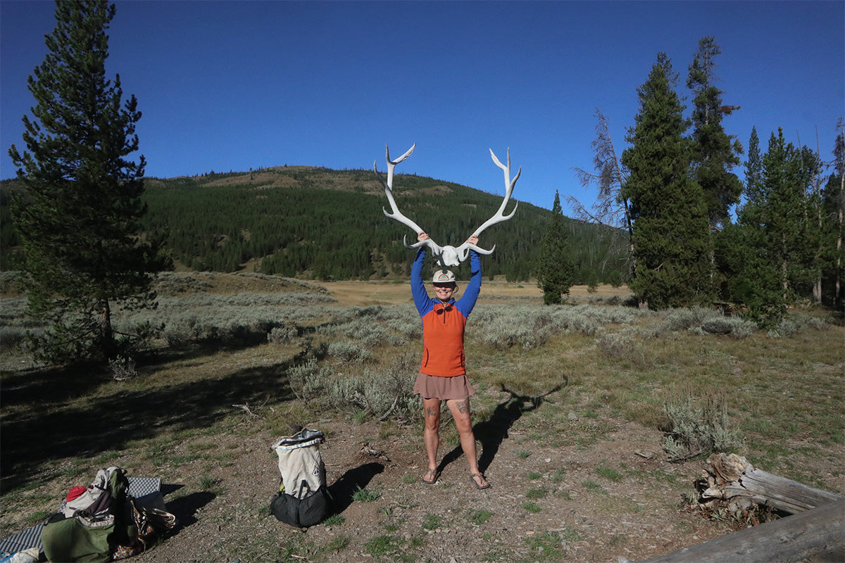
 As we continued making our way to camp, we listened to the bull elk bugling. This is their rutting time, and the bugles are so cool to hear. Our campsite was right on the Snake River, but due to bear activity, we didn’t have a bear hang that night; we had a bear box. This is a metal box that bears can’t open, so we put everything inside it. As we were walking to camp, a couple stopped us and told us that they had been woken up the night prior to the bear flipping over rocks in the same campsite we were headed to. I was excited, but Jon was nervous. We’d already spent so much time in grizzly territory, but we had yet to see one. I wanted to so bad! Unfortunately, no bear. There were some cool elk antler sheds that were scattered around the campsite, so the next morning before we left, we took some photos with them.
 Day five started pretty early too, as this was going to be our biggest elevation day. We had to climb a ridge to then drop into the Thorofare proper. The Bechler area is known as the most remote place in Yellowstone National Park, but the Thorofare is known as the most remote area in all of the lower 48. The Thorofare Ranger Station is the furthest building from any road in the lower 48, and we wanted to see it. Anyways, we woke up semi-early, which is like 9 am for Jon. We have a 4,000ft climb up to Big Game Ridge. The seasons are changing in this part of the park, and fall is starting to take hold. The colors are becoming stunning, and it kind of helped take your mind off the sucky climb. Unlike in Bechler, the fires of 1988 are quite noticeable over here in the southeast area of the park. Parts of the ground burned so hot that it completely sterilized the soil, so nothing can grow. The sun just beats down on you. The toothpicks, or the trees that are burned and are still standing from the '88 fires, tower over and swing in the wind. Someday they’ll fall, but hopefully not today. From the top of the ridge, we could see the Tetons, Yellowstone Lake, which is the largest freshwater lake in the lower 48, and the beautiful Thorofare Valley. The rivers that we’ve followed in this trek have such significance, but I will touch on those a little bit later on.
Our campsite tonight was going to be outside the park boundary. We once again met up with the CDT and hiked until we found a good site right on the Snake River. We were in charge of our own bear camp this night, and Jon found the perfect tree.
 Day six was exciting, because this meant that on the other side of Phelps Pass, we would actually be entering the Thorofare Valley, the most remote area. We realized we were getting remote when the trails I had on my phone were no longer trails on the ground. We decided to just follow the trails that we saw in front of us. Phelps Pass, which doesn’t seem like a pass at all, is nestled in the forest. Just north of the pass, though, are the headwaters of the Snake River. We hike parallel to Two Ocean Plateau, which isn’t just named that for kicks. It’s a rare geographic phenomenon where a single stream splits off the Continental Divide and finds itself flowing into both the Atlantic and Pacific Oceans. Parting of the Waters occurs here when the Snake River dumps into the Columbia River to then flow west to the Pacific Ocean, and the Yellowstone River flows north, meets up with the Mississippi River, and then eventually flows south and east to the Gulf and the Atlantic Ocean.
Before we climbed down from the Two Ocean Plateau, we had some beautiful views looking out over the Yellowstone River and the Thorofare Valley. We forded the Yellowstone River and then traversed along the shores of Bridger Lake, where we saw some beautiful swans. We forded Thorofare Creek and began our adventure of finding the Thorofare Ranger Station. We walked through more burn scar from the '88 fires, and the more you walk through it, the more you see how life always comes back. The next generation of lodgepole pine trees is growing beautifully after the fire. Fire truly is essential for these ecosystems.
 We finally saw a sign for the ranger station, and even though we knew nothing or nobody was going to be there, I wanted to get a picture of the sign on the station. It was cool to truly be this remote! We got to camp that night, and this was the first night I truly felt beat. Our campsite was quite a ways off the main trail, so I was just annoyed by the time we actually got there. It absolutely poured overnight, and we weren’t looking forward to the cold, wet, carwash we had waiting for us the next morning.
Day seven, our last full day on the trail. We spent the morning walking through some beautiful meadows with willows that were beginning to change from green to red to brown, and it was spectacular. The clouds were low from the overnight rains, and they hung in front of the mountains like you could reach out and touch them. It gave everything a nice ambiance. We had our eyes peeled in the meadows for grizzly and moose, both of which we had yet to see. Grizzlies have too long of claws to climb, so you usually find them in the meadows, whereas black bears have great climbing claws, so you’ll find them in the forested areas. We followed the Yellowstone River for a few miles before we got our first up-close view of Yellowstone Lake. The Yellowstone River is the longest, undammed river in the lower 48. It eventually dumps into the Missouri River, which then flows south, as I stated earlier. Not in this location, but the Missouri River also has its headwaters not far from here. The Missouri River is made up of the Gallatin River, whose headwaters are in the park; the Madison River, whose headwaters are in the park; and the Jefferson River, whose headwaters are not in the park and are a little further west than the other two. The rivers that we have in this part of the country, in Yellowstone National Park and in southwest Montana, have a lot of people and things depending on them. Yellowstone Lake is cool in its own way too. It’s the largest freshwater lake in the lower 48.
 You look out from its coastline, and it seems like you’re looking out over the ocean! After following the Yellowstone River for a bit, we then followed the coastline of the lake for the rest of the day. Thanks to the fires, we were provided with stunning views of the lake too, instead of being stuck in trees all day. We camped right on the shores of the lake that night, with our own rocky beach. We had views of islands out on the lake, and we fell asleep to the cold wind blowing inland from the water.
Day eight, our last morning on our trek through Yellowstone. The way our campsites were set up was that our last night would only be six miles from our ending trailhead, Nine Mile Trailhead. We made plans with Tags for him to pick us up at the trailhead at noon, so that meant another restful morning for me, and another “early” morning for Jon; we got moving around 10 am. Over these last six miles, we had beautiful views of the lake. I couldn’t help but spend these last couple of hours on the trail thinking about the adventure that we’ve just had. People truly spend their whole lives waiting to explore the Becher and the Thorofare.
 Logistics are really hard when planning something somewhere that is so remote. You have to figure out driving, flying, where you’ll start, where you’ll end, etc. You have to figure out timing–people with full-time jobs find it hard to take 8 days off. When you’re wanting to cover so much ground in such a short amount of time, you have to be able to move, too.
Yellowstone National Park is our backyard, and we still hear people around us talking about how they want to get in there and see these things, but it’s like no one ever finds the time or will to do it- but we did. The last few miles sure were bittersweet. We arrived at our trailhead, and Tags and his dog were already there in their van waiting for us. He scooped us up, and off to get food we went.
Yellowstone National Park is home to me, and it will always be. I’ve been to the park probably over 1,000 times, but this time was different. Exploring Bechler and the Thorofare had been on my list for many years now, and I’m grateful to have finally been able to do it, and to have been able to do it with my boyfriend, Jon, was an even better bonus. If you find yourself wanting to check out these places, don’t feel like you need to do both in one go! I don’t have a favorite between the two, as they were both so different. I think the Thorofare had more beauty, but Becher had so many insane waterfalls and areas you can soak in.
 Something I will mention is that it is totally illegal to get in any actual thermal features in the park. You can only get into places where hot creeks dump into cold rivers. There is so much to see out there, so what are you waiting for!?
Itinerary
Night 1: Campsite 9B7; 19 miles
Night 2: Campsite 9B2; 15 miles
Night 3: Campsite 9F2; 17 miles
Night 4: Campsite 8C2; 27 miles
Night 5: Out of Park; 17 miles
Night 6: Campsite 6Y5; 19 miles
Night 7: Campsite 5E9; 24 miles