


Words and Photos by Shaun Mittwollen
A tangled mess of Scorparia stifles forward progress at all costs pushing back with springy woody branches. Outside the spring flowering season, the plant is as unappealing as it sounds, with stiff leaves that penetrate bare skin like tiny hypodermic needles. Underfoot viscous mud bakes below an unrelenting sun, and it's a hard choice to decide what's more annoying.

Despite the constant saturation, clean water is difficult to find with tools such as 'yabbie straws' commonly used to siphon water from the burrows of the small crustaceans. Below the Southern Ocean, a ragged coast glistens like an azure jewel a mere few kilometres away. Corrugated groundswell refracts around offshore islands before rumbling ashore framed by towering sand dunes. This is undisturbed land. Next stop–South Antarctica. We are forging our way towards Australia's southernmost mountain range, the hugely remote and equally inspiring Precipitous Bluff.

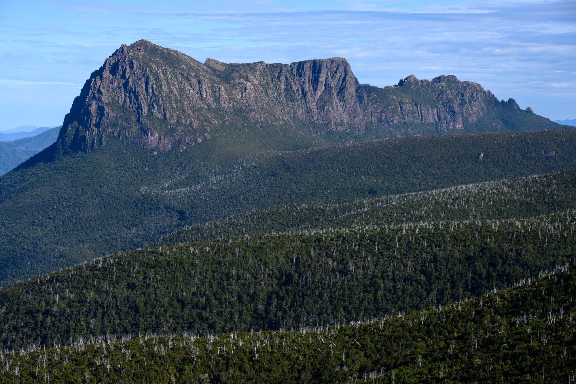
Precipitous Bluff, or PB as it's known for short, has a mystical reputation amongst the Tassie hiking community. Tales abound of the remote mountain rejecting very experienced hikers, either by a maze of false leads slowing the approach to an impossibly vague crawl, the dense prickly scrub irritating enough to abandon an attempt, or the fickle weather–at best baking 30c heat, or at worst a fight for survival with frigid winds, constant rain and or snow. So close to the south coast, a slight change in wind direction can shroud the summit in dense fog within minutes.

The summit plateau is guarded by a rim of towering dolerite cliffs impeding any probable route into the fortress, and its isolation from other mountains only adds to its focus. While it's not that the mountain is particularly tall by Tasmanian standards–1,145m–it's the combination of factors that makes the summit particularly hard to reach. It's a long approach that takes the average party three to five days in an area renowned for horrendous weather, no possible quick bail-out routes, dense scrub, and a constant mental battle instigated by the aforementioned. PB is one of the more committing mountains in Tasmania.

Foolishly, PB was the first hike I'd attempted in Tasmania with a group of friends back in 2016. Like many, we turned back just past Pindars Peak, where the scrub intensified. After letting it simmer for several years, it was time for a worthy reattempt. Zoe and I booked a two-week period off work last February and hoped for good weather. We were in luck. A viable weather window appeared.

As we pulled up to the carpark, a final few showers were passing overhead. Just a day earlier, it had been snowing on the peaks (keep in mind this is summer in Tasmania). We purposely sat lingering on breakfast, our best attempt to avoid starting in the rain. To me, there's nothing more demoralizing than starting a trip getting soaked. As we set off, the trail gained steep rainforest for several kilometres, juvenile Sassafras bursting from the forest floor, its large deep green leaves as showy as any tropical species. Below our feet, a myriad of cave systems with forty-meter vertical shafts and entrances festooned with brilliant blue glow worms.

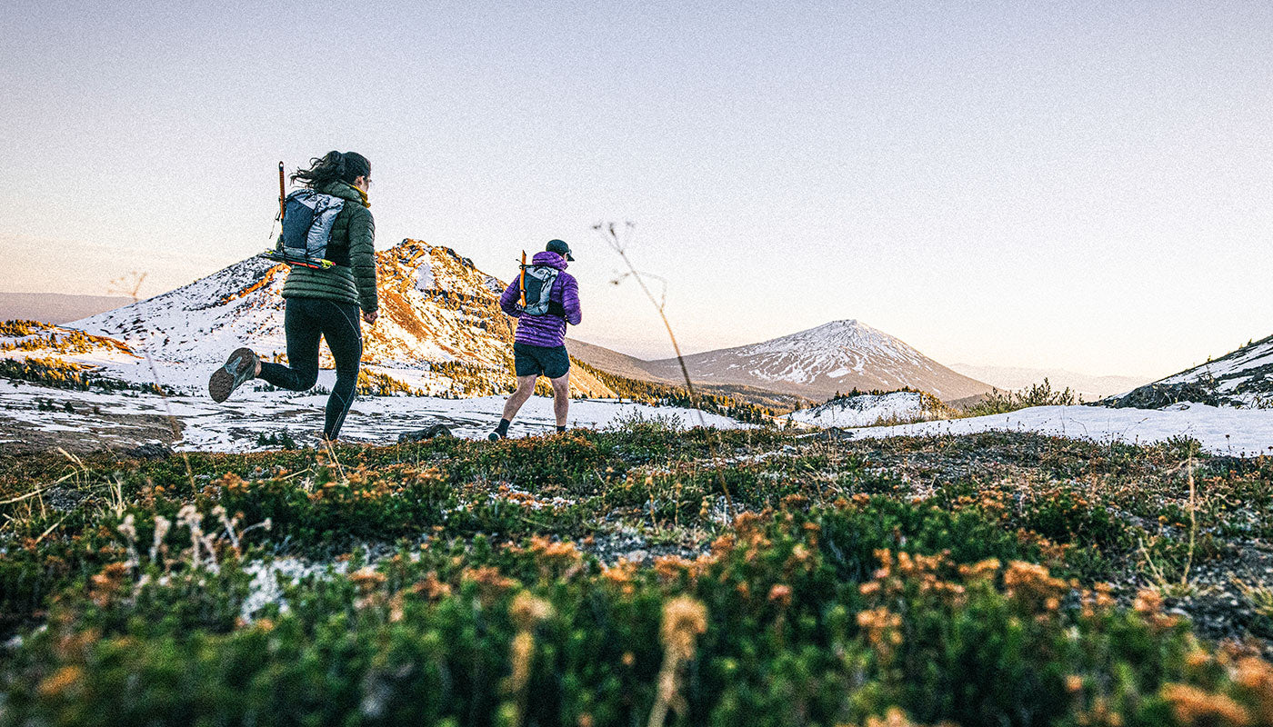
We climbed higher, and the plants became increasingly robust as we neared the exposed alpine zone. Here a long string of rounded peaks stretched out before us. The evidence of immense glaciation was obvious with u-shaped valleys, eroded cliffs, and off in the far distance PB, what would have been an isolated Nunatak during previous glaciation.

Small saddles separated each of the rounded hills, imaginatively named Hill 1, 2, and 3. Each saddle is a quintessential Tasmanian alpine garden of Cushion Plants and Pandani where the trail fanned out to prevent a track from forming. This was not a frequented trail, and it was hugely important to protect the delicate ecosystem and minimize trampling the slow-growing plant life. After several hours of easy walking along ridges, we dropped into the staggeringly beautiful Pigsty Ponds, a valley of alpine herbfields and crystalline glacial lakes, and our home for the first night. Although we had covered almost half the approach in terms of distance, the best was yet to come.

The next morning we ascended Pindars Peak, and here our isolation was readily apparent. Panning 360 degrees, there was no sign of civilization in any direction. No buildings, no people, and barely a visible track. This sense of remoteness, this sense of wilderness, is what makes hiking in Tasmania particularly special. A value rarely matched in our modern world. On the summit, the south coast was so close we could clearly hear the distant rumble of the swell. I spent time exploring the western arm off the peak and spotting a-frame sandbars up and down the remote Prion Beach that made me wish I had a surfboard stashed down there in the dunes. What's more, there looked like a line off the summit that would hold skiable snow. One for next winter, perhaps?

We descended off the peak, sidling westwards as the track disappeared into the dreaded scrub. Donning long sleeve shirts, pants, and gardening gloves, we plunged into the abyss. It was hard work, but our gardening attire was working a treat; the Scorparia couldn't penetrate, and it was almost a pleasantry to deal with the scrub without the feeling of being stabbed by thousands of tiny needles. "Maybe acupuncture patients just need to walk through Scorparia," I thought to myself. That night we made it as far as Leaning Tea Tree Saddle before we decided we were over it and set up camp. Leaning Tea Tree Saddle is named after its unique vegetation. Here on this exposed notch, constant westerly winds have sculpted the plants with a decided lean.

Day three began another morning wrangling with scrub in the summer heat. We were negotiating what the track notes described as a 'rough track' along the Kameruka Moraine on the final approach to the peak. This turned out to be more like a constant scramble over boulders that had been festooned with scrub in near tropical heat and UV-laden sun. It would be the worst possible spot for an injury, as we were days of slow walking from anywhere. With the heat and frustration of the scrub, Zoe had minutely misplaced a step. A sprained ankle.

Fortunately, Zoe has often sprained her ankle, and given her high tolerance for pain, we continued toward the summit. I had brought a concoction of medication and strapping just in case. Ibuprofen or "Vitamin I," codeine from when I busted my mouth open in the surf, and another unusual drug that a paramedic friend gave me before I skied off Federation Peak with the instructions. "Take this, and you can walk out with a broken knee." It sounded interesting, but we didn't test it out.

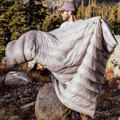
The peak loomed large, and the route up was difficult to pinpoint. A long line of cliffs surrounded the summit plateau without an obvious ascent gully. Shear in some places, the cliffs rose about 300m above the land. We ever trustingly followed the vague path forwards. In the heat, we were running low on water. The ground was saturated but undrinkable–thick mud with a stagnant oily sheen. It hadn't rained in days now. Several dark streaks stained the cliffs indicating the potential waterfall the track notes spoke of, and we climbed toward the source, gradually at first but then steeply up as we gained several rocky benches dissected by cliffs. With the sound of cascading water, a magical waterfall appeared, flowing down a gently angled dolerite gully. We refilled 5L of water each and couldn't help but have a quick swim in the tiny pool. The water was freezing, but as the saying goes, you never regret a swim.

For two nights, we camped on the summit of Precipitous Bluff. A rest day was spent exploring one of the most remote mountain plateaus in Tasmania. Our camp was just fifty meters away from some of the biggest cliffs I'd ever laid eyes on. The climbing looked epic. Slabby dolerite, overhangs and cracks. A steep couloir with a needle-like central ridge almost looked skiable. If only for the access.

Hundreds of meters below the slope cut downwards towards the New River Lagoon, our escape to the South Coast Track. From the summit, a panorama of oceanic and mountain scenery. Offshore quartzite islands glistened in the sun. It was some of the warmest weather we'd had all summer. To the north, Federation Peak surrounded by minor hills. Areas of wilderness where you could count on one hand the number of human visitors. The ocean was only a few kilometres below, but the horizon line was well over one hundred. Next stop Antarctica.